
Travel Planning · 7 min read
Da Nang Map: Districts, Beaches, Bridges and Where Things Are
Understanding the Da Nang map before you arrive saves hours of confusion on the ground. This guide breaks down every district, beach zone, bridge and landmark so you know exactly where things are.
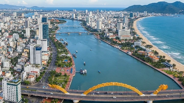
Understanding the Da Nang Map Before You Arrive
The Da Nang map is simpler than it looks once you understand one core idea: the city splits into two zones divided by the Han River. The west bank holds the urban core, markets, the train station and most budget accommodation. The east bank is the beach strip, running from Son Tra Peninsula in the north down to the Marble Mountains in the south. Everything in Da Nang falls into one of these two zones, and a handful of bridges connect them. Once that mental model clicks, navigating becomes straightforward.
For real-time navigation, use Google Maps or the Grab app. For a curated view of vetted venues, restaurants and activities, use the Da Nang Directory interactive map to filter by category and area before you leave your hotel.
The Han River: Da Nang's Dividing Line
The Han River runs roughly north to south through the middle of Da Nang. It is not wide, and crossing it takes under five minutes by bridge. But understanding which side you are on is the single most useful piece of orientation you can have.
West bank (city side): Han Market, Con Market, Da Nang Cathedral, the train station, Cham Sculpture Museum, government buildings and most of the local residential streets.
East bank (beach side): My Khe Beach, the resort hotel strip, beach clubs, surf schools and the road south to Non Nuoc Beach and the Marble Mountains.
The Main Bridges
There are six bridges crossing the Han River in the city area. These three matter most for visitors:
- Dragon Bridge (Cau Rong): The most famous. Connects Tran Phu on the west to Pham Van Dong on the east. Hosts a fire and water show every Saturday and Sunday night at 9pm (confirm locally, as of November 2026).
- Han River Bridge (Cau Quay Han): The swing bridge near Han Market. A Da Nang landmark, though it swings open at night for boat traffic and can interrupt crossings.
- Nguyen Van Troi and Tran Thi Ly Bridges: A pair of parallel bridges further north, useful for reaching Son Tra Peninsula without using Dragon Bridge.
Da Nang Districts: A Practical Breakdown
Da Nang has seven main administrative districts. For travelers, four matter most.
| District | Zone | What's There | Best For | |---|---|---|---| | Hai Chau | West bank | Han Market, Cathedral, Cham Museum, restaurants | First-timers, city exploration | | Son Tra | East/north | My Khe Beach, Linh Ung Pagoda, Lady Buddha | Beach stays, seafood, hiking | | Ngu Hanh Son | East/south | Non Nuoc Beach, Marble Mountains, stone carving villages | Day trips, culture | | Cam Le | West/south | Local residential, Lotte Mart, budget apartments | Long-stay expats | | Lien Chieu | Northwest | New port under development, outer suburbs | Mostly transit | | Thanh Khe | West | Mostly residential, local markets | Little for tourists | | Hoa Vang | Rural west | Ba Na Hills, farming villages | Day trips |
The Beach Zone: North to South
The east bank coastline is roughly 30 kilometers long. Here is how it breaks down from north to south.
Son Tra Peninsula (North)
The peninsula juts northeast into the sea above the main beach strip. It is home to Man Thai Beach, a quieter bay popular with locals for morning swimming, and the road up to Linh Ung Pagoda and the Lady Buddha statue. The peninsula is hilly, green and much less developed than My Khe. Traffic on the summit road is light, making it a good motorbike loop.
My Khe Beach (Central)
My Khe Beach is the main event. It runs for around 10 kilometers along the east bank, starting just across Dragon Bridge and heading south. This is where you will find the resort hotels, surf rental shops, beach volleyball nets and the majority of tourist-facing restaurants. The water is clear from February to August. Mornings here are busy with locals exercising. The beach is free to access.
Thanh Binh Beach (Northwest Fringe)
Bien Thanh Binh sits at the northern end of the beach zone in Hai Chau district, closer to the city center. It is less polished than My Khe and mainly used by locals. Useful if you are staying on the west bank and want a quick swim without crossing a bridge.
Non Nuoc Beach and Ngu Hanh Son (South)
About 10 kilometers south of the city center, Non Nuoc Beach is wider, calmer and backed by luxury resorts rather than mid-range hotels. The Marble Mountains (Ngu Hanh Son) sit just inland here, five limestone hills with caves, pagodas and viewpoints. Entrance is 40,000 VND; the one-way elevator costs 15,000 VND extra (as of November 2026, confirm locally). From the top you get one of the best orientation views of the Da Nang map in real life.
The City Side: Key Landmarks and How They Cluster
Hai Chau Core
This is the historical and commercial center. The main landmarks are within walking distance of each other:
- Han Market: A covered wet market two blocks from the river. Good for fresh produce, street food and cheap souvenirs.
- Da Nang Cathedral: The pink church on Tran Phu street, a short walk from Han Market.
- Cham Sculpture Museum: On the corner of Tran Phu and Bach Dang, overlooking the river. Entrance 60,000 VND (as of November 2026, confirm locally). Houses the world's largest collection of Cham sandstone sculptures.
- Bach Dang riverside strip: The promenade running along the west bank. Popular at sunset for street food carts and local families.
Transport Nodes
- Da Nang International Airport (DAD): Sits inside the city, about 3 kilometers southwest of Hai Chau center. Grab is the easiest exit option; note a 10,000 VND airport toll is added to fares.
- Da Nang Train Station: On Hai Phong street in Thanh Khe district, about 2 kilometers northwest of Hai Chau center. Trains run north to Hue (roughly 2.5 hours) and south to Ho Chi Minh City.
- Tien Sa Port: On the Son Tra Peninsula, northeast of the city. Cruise ships dock here.
Getting Between Zones: Bridge Tips
The most common mistake visitors make is underestimating bridge traffic during rush hours (7am to 8:30am and 5pm to 6:30pm). If you are Grabbing from the beach side to the airport during these windows, add 15 to 20 minutes to your estimate.
Dragon Bridge is visually impressive but also the most congested. For faster crossings during peak hours, ask your Grab driver to use Tran Thi Ly Bridge instead.
Essential Services on the Map
Pharmacies
Pharmacity and Long Chau are the two reliable chains. Both have multiple branches across Hai Chau and Son Tra districts. Search for the nearest branch on Google Maps before you need one rather than after.
ATMs
VPBank, TPBank and Vietcombank are the most reliable for international cards with lower fees. There are clusters near Han Market, along Bach Dang riverside and inside Vincom Plaza on Nguyen Van Linh. Avoid standalone ATMs in tourist spots that charge elevated withdrawal fees.
Hospitals
C Hospital (Benh Vien C) on Le Duan street is the main public hospital. For English-speaking care, Family Medical Practice and Vinmec Da Nang are in the Son Tra and Ngu Hanh Son areas respectively.
Orientation Tips Before You Open Any Map App
- Face the sea and you are facing east. The Han River is behind you, to your west.
- The airport is southwest of everything. If you are heading there, you are heading away from both the beach and the river.
- Ba Na Hills is not on the coastal map. It is 25 to 30 kilometers west into the mountains, about 45 minutes by car from the city center.
- Hoi An is 30 kilometers south. From Non Nuoc Beach, Hoi An is a 30 to 40 minute drive down Highway 1.
- Hue is north. About 100 kilometers north over Hai Van Pass or through the tunnel.
For a deeper dive into food locations across these zones, see the Da Nang Culinary Map: Where to Find Authentic Local Flavors. For tips on turning this geographic knowledge into a day-by-day plan, read How to Use Interactive Maps to Plan Your Perfect Da Nang Itinerary.
Use the Directory Map to Filter What Matters to You
Static maps show you roads. The Da Nang Directory map at /explore?view=map lets you filter by category, area and budget so you only see what is relevant to your trip. Looking for beachside seafood restaurants in Son Tra? Filter for it. Want coworking spaces within walking distance of My Khe? Filter for that too. It is the fastest way to build a mental picture of the city before you land.
Quick answers
- What are the two main zones on the Da Nang map?
- Da Nang divides into the city side on the west bank of the Han River and the beach side on the east bank. The city side holds markets, museums and the train station. The beach side runs from Son Tra Peninsula in the north down to the Marble Mountains and Non Nuoc Beach in the south. Several bridges connect both zones.
- Which bridge in Da Nang is the most famous?
- Dragon Bridge is the most iconic landmark on the Da Nang map. It connects the Hai Chau city center to the My Khe beach strip and hosts a fire and water show every Saturday and Sunday night at 9pm, as of November 2026. Confirm the schedule locally as times can change around holidays.
- How far is Ba Na Hills from the Da Nang city center?
- Ba Na Hills is about 25 to 30 kilometers west of the city center, heading into the mountains. The drive takes roughly 45 minutes by car or Grab. It does not appear on the coastal section of the Da Nang map and requires a separate trip away from the beach and river areas.
- How far is Hoi An from Da Nang on the map?
- Hoi An is approximately 30 kilometers south of Da Nang city center, about 30 to 45 minutes by Grab or private car depending on traffic. The route runs south along the coast past Non Nuoc Beach and the Marble Mountains before reaching Hoi An Ancient Town.
- Where is Da Nang airport on the map?
- Da Nang International Airport sits inside the city boundary, roughly 3 kilometers southwest of the Hai Chau district center. It is close to both the city side and beach side, making transfers quick. A Grab from the airport to My Khe Beach typically takes 10 to 15 minutes depending on traffic.
- What is the easiest way to navigate Da Nang?
- Google Maps handles real-time navigation well. Use Grab for motorbike or car rides, as fares are fixed upfront and you avoid price negotiation. For finding specific vetted venues by category and neighborhood, the Da Nang Directory interactive map at danangdirectory.com/explore lets you filter results before you leave your accommodation.
- Is the Da Nang map easy to understand for first-timers?
- Yes. The city is compact and logically laid out. Once you know the Han River divides east from west, and that most tourist activity happens within a few kilometers of the river or coastline, orientation is simple. The main confusion is that Ba Na Hills and Hai Van Pass sit well outside the central city map area.
More on Travel Planning
All Travel Planning articles

Han Market Da Nang: The Complete Visitor Guide
Han Market is Da Nang's most tourist-friendly market, packed with dried goods, local coffee, souvenirs, and a full upper floor of fabrics and tailors. This guide covers every floor, fair prices, bargaining tips, and where to eat nearby.


Central Vietnam Itinerary: Da Nang Base for Hue, Hoi An and More
Da Nang sits at the heart of Central Vietnam, putting Hue, Hoi An, My Son and the Hai Van Pass all within easy day-trip distance. This itinerary covers exactly how to do it, with transport times, current prices and insider tips.


Da Nang in January: Weather, Tet Tips and What to Do
January in Da Nang brings mild temperatures, occasional drizzle, and the buzz of approaching Tet. Here is everything you need to plan a smart, rewarding trip this month.
 Translate
