
Travel Planning · 7 min read
Da Nang Flood and Typhoon Season: What Travelers Must Know
Da Nang flood and typhoon season runs roughly from September to December, with October being the most intense month. Here is everything you need to know to stay safe, check warnings and manage your trip if the weather turns.
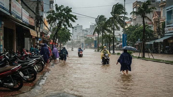
Da Nang Flood and Typhoon Season: What You Need to Know
Da Nang flood risk is real and worth understanding before you book. The city sits on the central Vietnamese coast and is directly in the path of the northeast monsoon, meaning heavy rain, urban flooding, and occasional typhoons are a genuine part of life here from September through December. October is consistently the most dangerous month. If your trip falls in this window, this guide covers exactly when the risks peak, how to track warnings in real time, and what to do if flooding or a da nang typhoon overlaps with your visit.
When Does Flood and Typhoon Season Happen in Da Nang?
Da Nang has two distinct seasons. The dry season runs from roughly February to August, with the best beach weather falling between March and May. The wet season begins in September and typically eases by late December or early January.
Month-by-Month Risk Breakdown
| Month | Flood Risk | Typhoon Risk | Typical Conditions | |---|---|---|---| | January | Low | Very Low | Occasional cool showers | | February | Low | Very Low | Drying out, pleasant | | March to May | Very Low | Very Low | Best travel months | | June to August | Low | Low | Hot, mostly dry | | September | Moderate | Moderate | Rains increasing | | October | High | High | Peak flood and typhoon risk | | November | High | Moderate | Continued heavy rain | | December | Moderate | Low | Easing but still wet |
As of October 2026, Da Nang has experienced significant urban flooding on major streets including Hung Vuong Street, Trung Nu Vuong Street, and Nguyen Chi Thanh Street, along with landslides in mountainous districts. The Global Flood Awareness System (GloFAS) and Copernicus Emergency Management Service (CEMS) both flagged widespread flooding across central Vietnam during this period. Military personnel were mobilised to assist with evacuations in affected communes.
What Causes Da Nang Flooding?
Several factors combine to make central Vietnam particularly vulnerable:
- Northeast monsoon: Drives persistent, heavy rainfall from September onward
- Typhoon tracks: Tropical storms that form in the South China Sea or western Pacific frequently make landfall along the central Vietnamese coast
- Geography: Da Nang is hemmed between the sea and the Truong Son mountain range, funnelling runoff directly into low-lying city streets
- Urban drainage: Rapid city development has outpaced drainage infrastructure in some districts
- Flash flood zones: As of October 2026, 47 communes and wards within Da Nang are officially identified as at risk for flash floods and landslides
Areas Most at Risk
- City centre streets: Low-lying roads near the Han River flood first
- Mountainous districts: Hoa Vang district and areas toward the Hai Van Pass are prone to landslides during sustained rainfall
- Son Tra Peninsula approaches: Single road access makes this area vulnerable to being cut off
- Southern Da Nang: Areas like Nui Thanh commune have seen severe, less-frequent flooding events requiring evacuations
Da Nang Typhoon: What to Expect
A da nang typhoon is not just heavy rain. When a named storm makes landfall or passes close to the coast, you can expect:
- Sustained winds of 60 to 150+ km/h depending on storm category
- Storm surge that pushes seawater inland along My Khe and other beach areas
- Flight cancellations and airport closures at Da Nang International Airport (DAD)
- Bridge and road closures, including the Dragon Bridge and coastal roads
- Power outages lasting hours to several days
- Mandatory evacuation orders in coastal wards
Typhoon season overlaps almost exactly with flood season, peaking in October and November. The Vietnamese government classifies storms by level, and local authorities issue mandatory shelter orders when a storm is forecast to make direct landfall.
How to Check Flood and Typhoon Warnings
Do not rely on a single source. Use a combination of the following:
Official Vietnamese Sources
- Vietnam Meteorological and Hydrological Administration (VNMHA): nchmf.gov.vn publishes daily forecasts and storm warnings in Vietnamese and some English
- Da Nang city government announcements: danang.gov.vn and the city's official Facebook page post emergency updates
- Local news outlets: Tuoi Tre (tuoitre.vn) and Lao Dong (laodong.vn) cover flooding events in near real time
International Tools
- GloFAS (Global Flood Awareness System): global.copernicus.eu, run by the Copernicus Emergency Management Service, provides flood forecasting up to 30 days ahead
- Joint Typhoon Warning Center (JTWC): metoc.navy.mil issues official typhoon tracks and intensity forecasts
- Weather apps: AccuWeather and Windy (windy.com) give hour-by-hour forecasts and are widely used by travellers in Vietnam
On the Ground
- Grab drivers and guesthouse staff are often the fastest source of local road condition updates
- Hotel front desks in Da Nang are experienced with storm season and will notify guests of official orders
What to Do If Your Trip Overlaps with Flooding or a Typhoon
Before You Arrive
- Check the forecast 5 to 7 days out using GloFAS or JTWC
- Purchase travel insurance that explicitly covers natural disaster trip cancellations and delays. Many standard policies exclude named storms if the event was already known at booking time
- Register with your country's embassy or consulate in Hanoi or Ho Chi Minh City. Most embassies have a traveller registration system and will send SMS or email alerts during declared emergencies
- Save the emergency number for Da Nang police (113), fire (114), and ambulance (115) in your phone
If You Are Already in Da Nang
- Stay off flooded streets. Floodwater in Da Nang city streets can be deceptively deep and moves fast. Never attempt to drive or walk through visibly flooded roads
- Avoid mountainous areas. Day trips toward Bach Ma, the Hai Van Pass or inland Hoa Vang district should be cancelled immediately when heavy rain warnings are issued
- Move to upper floors. If your accommodation is ground level and flooding starts, move valuables and yourself upstairs
- Keep devices charged. Power outages are common. A portable power bank is essential
- Bottled water only. Floodwater contaminates the tap water supply. Stock at least two litres per person per day
- Follow official orders. If local authorities issue an evacuation order for your area, comply immediately
- Check your flight. Da Nang International Airport suspends operations when wind speeds exceed safe thresholds. Contact your airline directly and check the airport's official website or departure boards
Indoor Alternatives While Waiting Out the Rain
If you are stuck inside, Da Nang has solid options. Vincom Plaza Da Nang is a large indoor mall with a cinema, food court, and dozens of shops, and it stays open during rain. Many cafes around An Thuong and the Han River area are perfectly suited to waiting out a downpour with a ca phe sua da. If you need to pass time productively, browse our full city guide at /explore.
Packing for Wet Season Travel
If you are visiting between September and December, pack or buy locally:
- A compact, wind-resistant umbrella (sold everywhere in Da Nang for 50,000 to 80,000 VND as of October 2026, confirm locally)
- A lightweight waterproof poncho (essential for motorbike riders)
- Waterproof sandals or shoes with grip
- A dry bag or waterproof cover for your daypack
- Power bank of at least 20,000 mAh
- A small supply of bottled water and snacks in case movement is restricted
If you need any additional gear or clothing, tailors and market stalls around Con Market can help. See our guide to Getting Clothes Tailored in Da Nang for more on adapting your wardrobe locally.
Should You Cancel Your Trip?
That depends on timing. A confirmed typhoon making direct landfall on Da Nang is a reason to delay or reroute. General rainy season conditions, while inconvenient, do not necessarily ruin a trip. Many travellers visit in October and November and have a perfectly good time with flexible planning.
The honest advice: if JTWC or VNMHA is forecasting a Category 2 or higher storm within 72 hours of your arrival, contact your airline and accommodation immediately about rescheduling. Most reputable hotels in Da Nang have storm-season policies and will work with you.
For general context on when to visit and how to plan, our One Day in Da Nang: A Layover Itinerary That Actually Works guide includes timing notes that apply to multi-day planning too.
A few basic Vietnamese phrases are also worth having ready. Knowing how to ask for help or understand a basic warning sign matters more than ever when weather turns. See our Useful Vietnamese Phrases for Your Da Nang Trip for a quick reference.
Quick Reference: Emergency Contacts and Resources
| Resource | Details | |---|---| | Police | 113 | | Fire | 114 | | Ambulance | 115 | | Da Nang City Government | danang.gov.vn | | Vietnam Meteorological Authority | nchmf.gov.vn | | Typhoon Tracking | metoc.navy.mil (JTWC) | | Flood Forecasting | global.copernicus.eu (GloFAS) | | Real-time Weather | windy.com |
Stay informed, stay flexible, and do not underestimate central Vietnam's wet season. Browse the full Da Nang Directory for vetted indoor venues, restaurants and essentials that are open year round at /explore.
Quick answers
- Is it safe to travel to Da Nang in October?
- October is the highest-risk month for flooding and typhoons in Da Nang. Travel is possible but requires close monitoring of weather forecasts. Check VNMHA and JTWC in the week before arrival. If a named typhoon is forecast to make direct landfall, seriously consider rescheduling your trip.
- How long does the rainy season last in Da Nang?
- The rainy season in Da Nang typically runs from September through December, driven by the northeast monsoon. October and November carry the highest flood and typhoon risk. The dry season, with the most reliable weather for outdoor activities, runs from approximately February to August.
- What should I do if I am in Da Nang during a flood?
- Stay off flooded streets, avoid mountainous areas due to landslide risk, move to upper floors if your accommodation is low-lying, keep devices charged, drink only bottled water, and follow all instructions from local authorities. Save the Da Nang emergency numbers: police 113, fire 114, ambulance 115.
- Are flights to Da Nang affected by typhoons?
- Yes. Da Nang International Airport suspends operations when wind speeds exceed safe thresholds during a typhoon. Check your airline directly and monitor the airport departures board. Airlines typically offer fee-free rescheduling when a typhoon warning is officially declared for Da Nang.
- Are landslides common in Da Nang during heavy rain?
- Yes, particularly in mountainous districts like Hoa Vang and along routes toward the Hai Van Pass and Bach Ma National Park. As of October 2026, 47 communes and wards within Da Nang are officially classified as at risk for flash floods and landslides during sustained rainfall periods.
- Where can I find official flood and typhoon warnings for Da Nang?
- Use Vietnam's meteorological authority at nchmf.gov.vn, the Da Nang city government site at danang.gov.vn, the Joint Typhoon Warning Center at metoc.navy.mil, and the Copernicus GloFAS flood forecasting system. Local news outlets Tuoi Tre and Lao Dong also post near real-time flood updates.
- Is tap water safe to drink in Da Nang during a flood?
- No. Floodwater can contaminate the tap water supply. During and immediately after a flooding event, drink only bottled water. Stock at least two litres per person per day if movement is restricted. Follow any boil-water advisories issued by Da Nang city health authorities.
More on Travel Planning
All Travel Planning articles

Da Nang in November: Weather, Tips and What to Expect
November is Da Nang's wettest month, with heavy rain on up to 28 days and real flood risk. Here is everything you need to plan a smart, flexible trip.


Da Nang Mall Guide: Aeon, Lotte Mart, Vincom and More
Da Nang now has more mall options than ever, from the brand-new Aeon Mall to longtime favorites like Lotte Mart and Vincom Plaza. This guide tells you exactly what each one is best for and how to get there.

40 Best Things to Do in Da Nang: The Complete 2027 Guide
From sunrise swims at My Khe to fire-breathing dragons over the Han River, Da Nang packs an enormous range of experiences into one compact city. This guide covers the 40 best things to do in Da Nang, with prices, timings, and insider tips for every budget.